|
Arizona - Route 66
Arizona Road Segments
Arizona Route 66 has its roots in the ancient past with aboriginal trails that linked trade partners from the Great Plains to coastal California. Used for centuries, these trails followed gentle terrain and led to water sources. After the United States acquired lands in the Southwest from Mexico in 1848, Congress sent exploratory parties to the area to assess its resources and search for transportation routes. Between 1857 and 1859, Lieutenant Edward Fitzgerald Beale traversed one such route, when he constructed a wagon road between Fort Smith, Arkansas and the Colorado River along the 35th Parallel, a relatively level terrain with a mild climate. In the final decades of the 1800s, the Beale Wagon Road guided thousands of settlers, ranchers, military personnel, and others west. Railroad engineers followed the path of the Beale Road when surveying for the 1883 transcontinental Atlantic and Pacific Railroad. Towns and settlements soon grew up along the railroad, and roads linked the towns’ main streets. Route 66 stems from these foundations.
During the Territorial years from 1863 to 1912, Arizona had an inadequate road system. Individual counties had authority over road construction but generally lacked the tax revenues or organization to carry out an effective road construction and maintenance program. Arizona became a State in 1912. The advent of the automobile in the early years of the 20th century revolutionized the concept of road building in Arizona and ushered in a boom in road construction activity. In the second decade of the 20th century, coast-to-coast and regional highways developed, largely due to the influence of the Good Roads movement. The Arizona Good Roads Association published a tour book with road maps in 1913 to publicize the State’s roads. In it, the publishers proclaimed that, “… Arizona has … the best natural roads in the Union,” but also conceded that, “… some difficulties are encountered in the remote sections.” These difficult sections included the future path of Route 66.
Years passed before travelers in the northern part of Arizona saw any substantial improvement in the roads. Arizona could not keep pace with the enormous demand for roads by a public increasingly fascinated with the automobile, and counties did not have adequate funding or organization to take on the responsibility. After Congress passed the Federal Aid Road Act (also known as the Bankhead Act) in 1916, Arizona received $3.7 million. Dirt roads were graded, cinder surfaced, and widened, and new bridges and culverts were constructed at canyon and river crossings. The road across northern Arizona, known as the National Old Trails Highway, was part of a transcontinental route that linked segments of old trail. The United States Government considered several routes to pave as part of the nation’s first system of Federal highways, and promoters of the Old Trails Highway eventually convinced the government of the route’s worthiness leading to its designation as part of U.S. Route 66 in 1926. Some 400 miles of Route 66 passed through Arizona, and in 1926, virtually none of it was paved.
Arizona, as elsewhere, experienced an explosive increase in automobile use during the 1920s, and as traffic increased, engineering standards were no longer adequate for the heavy road use. The outmoded 1920s roadways needed rebuilding, straightening, and reengineering. Paving of Route 66 began with the main streets of towns, which helped fund the projects, making Route 66 the “Main Street of America.” Arizona received more than $5 million of National Recovery Administration highway funds in 1933 as part of President Roosevelt’s sweeping unemployment relief programs, and by 1938, Route 66 was completely paved from Chicago to Los Angeles.
As the economy improved in the late 1930s, Americans began to take vacations by automobile, and the scenic wonders along Route 66 were a major destination. Arizona offered many attractions: National Parks like Petrified Forest and the Grand Canyon, cool mountain vistas, and the Navajo reservation. America had a love affair with American Indian culture, fueled by popular “Cowboy and Indian” motion pictures. Western movies conveyed a stereotyped image of Indian tribes, one perpetuated by business owners along the way. Although teepees and war bonnets associated with the Plains tribes were not authentic to Arizona, they became the banner of Route 66 found in curio shops and on neon signs and billboards.
After World War II, tourism, growth, and development boomed in Arizona. Post-war prosperity brought an unprecedented increase in automobile travel to the State, and to Route 66 in particular. Towns once again buzzed with activity, and cash registers rang the chime of good times.
Although Route 66 received constant maintenance through the years, traffic congestion worsened, especially in the small towns along the way. One in seven accidents in Arizona occurred on Route 66, giving rise to another, less flattering, name for the road: Bloody 66. The realignment of some sections straightened out particularly dangerous curves--the famous Ash Fork Hill in 1950 and the Oatman grade in 1951 are two notable examples. Nevertheless, the highway was obviously out of date and too congested.
The Federal Aid Highway Act of 1956, known as the National Interstate and Defense Highways Act, appropriated billions of dollars to build interstate highways. The new system of interstates would conform to new design standards that included limited access, a minimum of two traffic lanes in each direction, and bypasses around every city and town along the way. Work soon began on the new highway in Arizona, now designated Interstate 40. It took more than a decade and over $375 million before much of it was open to traffic. By bypassing several sections of winding road, Interstate 40 reduced the mileage across Arizona from 376 miles to 359 miles. The final section of the entire national length of Route 66 to be bypassed was a six-mile stretch through the town of Williams, Arizona on October 13, 1984. This momentous occasion was marked by a ceremony in Williams in which Bobby Troup sang his famous song “Route 66.”
The Road Segments
Route 66 road segments listed in the National Register of Historic Places are described in geographical order from east to west. Of particular interest are the road segments in the Parks area where visitors can view the evolution of Route 66 through this small community. Abandoned segments dating from 1921 and 1931 are still extant, illustrating the various alignments and the road’s relationship to the town of Parks.
Brannigan Park to Parks (1931)
The most recent iteration of Route 66 through the area, this 6.5 mile segment passes through the scenic high country of the Coconino Plateau, beginning at the open watered meadows of Pitman Valley, ascending Oak Hill to Garland Prairie Vista, and ending at the small community of Parks. During the Mother Road’s heyday, this segment offered travelers many scenic attractions and amenities. Midway between Flagstaff and Williams, the community of Parks had a small store, gas station, restaurant, school, post office, spring water and campground. Just north and west of Parks, the Fireside Inn offered tourist cabins, gas, and a barbeque lunch counter. Continuing west, campers could stay at Spitz Springs Forest Camp or the scenic Garland Prairie Vista with its spectacular view of the San Francisco Peaks. In Pitman Valley, the McHat Inn provided guest cabins and a filling station. The Elmo Dance Hall was across the road. The one tourist amenity remaining in operation is the Pines General Store and Post Office in Parks, which opened in 1933. This road segment was built in 1931 and replaced a circa 1920 alignment located to the south. Arizona Highways Magazine proclaimed in 1931 that construction of this section would “… eliminate 18 miles of narrow, crooked, poorly surfaced road which is particularly dangerous in dry weather due to raveling and innumerable potholes.” The new road featured a straight alignment, improved road surface, and standard concrete box culverts. Upgraded again in 1939 with new pavement, this section still has several miles of Portland cement still in place. A slight realignment in 1941 abandoned about a mile of the road. Coconino County assumed responsibility for this overall segment with the completion of Interstate 40 in 1964.
Abandoned Route 66: Town of Parks (1931)
Built in 1931, this abandoned .85-mile segment of Route 66 was part of the realignment connecting Brannigan Park and Parks (described above). When the road was realigned again in 1941 near Parks, this segment was abandoned. This section retains its asphalt pavement and concrete culverts, and despite some deterioration of the road surface has changed little in appearance since its 1931 construction.
Abandoned Route 66: Town of Parks (1921)
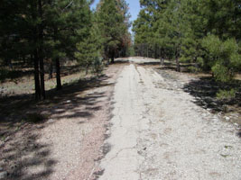
This .35-mile segment predates the 1931 alignment of Route 66. Constructed in 1921 and designated as Route 66 in 1926, it was abandoned during the 1931 realignment. Although pre-1930s alignments were generally unpaved, this section appears to have a bituminous surface, formed by spraying hot oil on pebbles or cinders. Arizona Highways Magazine referred to this segment in 1931 as a “narrow, crooked, poorly surfaced road which is particularly dangerous in dry weather due to raveling and innumerable potholes.” A sharp curve just west of this segment earned the dreaded title of dead man’s curve in the local newspaper after numerous accidents. The 1931 realignment that abandoned this segment straightened and widened Route 66, necessitating a shift in the roadbed (described above). This short section of road is an excellent example of one of the earliest alignments of Route 66. It is the best-preserved section of the circa 1921 roadway in the Parks area, and although it is only .35 miles long, the segment presents an unbroken view of the roadway to the horizon.
Williams
Williams has the honor of being the very last town on Route 66 bypassed by the interstate. In 1921, downtown Williams had a 1.6-mile graded and cindered roadbed that had replaced an earlier muddy track. It was paved with Portland cement in two separate projects: the west end in 1928 and the east end in 1932. Population centers tended to be the first parts of Route 66 to be paved. Organized towns not only lobbied hard for pavement but also had the money to pay for it. Construction of motels, restaurants, curio shops and gas stations soon boomed on the east end of Williams creating the Williams Historic Business District.
These businesses far outnumbered the traveler-related businesses on the west end of town, supporting the theory that towns along Route 66 tended to expand eastward to capture the abundant westbound traffic. In 1957, the Arizona Highway Department built a new overpass on the east end of town and dedicated Route 66 for westbound traffic. On October 13, 1984, Interstate 40 bypassed Route 66 through the center of town. Williams still looks much as it did in the 1940's with its numerous curio shops, motels and cafes. In both function and appearance, Williams embodies the spirit of historic Route 66.
Pine Springs Section
This 1.1-mile section of Route 66 dates from 1932-33. In 1950, realignment up Ash Fork Hill bypassed this segment, but local access to Pine Springs Ranch on the south side of the road was maintained. In 1966, ownership of the road transferred to the Kaibab National Forest. The Forest Service requested that the Arizona Highway Department fulfill its right-of-way permit obligations to remove all structures and improvements and restore the site to its natural appearance. The Forest Service requested to “have this old highway ripped up, the concrete culvert ends demolished, and the entire area revegetated.” Only this 1.1-mile section survived the obliteration of the roadway east and west of Pine Springs Ranch.
Ash Fork Hill
Two road segments are located in the Ash Fork Hill area, one dating back to 1921-22 and the other to 1932-33. Both segments were designed to ascend Ash Fork Hill, a 1,700 foot incline that was one of the steepest sections along the entire length of Route 66. The 1921-22 road was built in two sections and was never paved. The western section was 4.8 miles long and the eastern section 2.8 miles in length. The 1932-33 road, which was eventually paved, was an 8.2 mile long stretch and followed the same general direction of the earlier road. Despite the 1932-33 realignment, the Ash Fork Hill roadway plagued travelers, especially when traffic increased in the 1940s. In 1950, the road was again realigned and a steep grade was built straight up the canyon. Interstate 40 was later built on top of the 1950 alignment. The two earlier segments were officially abandoned in 1964 to the Kaibab National Forest, but the roads were left intact and even the guard rails still stand along sections of the 1932-33 roadway. These roads are closed to the public today except for a short section of the 1921-22 road that is used for local access.
|
Brannigan Park to Parks, AZ: This segment is actively used as a local access road. Driving west from Flagstaff on I-40, take exit 185. Turn right and then left onto the Frontage Rd. Head west for 2.2 miles. The Frontage Rd. closely parallels I-40 until it heads northwest toward Brannigan Park. At 2.5 miles, you will enter the Kaibab National Forest where you will find a Route 66 roadside interpretive sign giving history of the road. The sign has a good map of Route 66 alignments in the area. The National Register district begins at Brannigan Park (3.9 miles) where the pavement ends, and the road becomes gravel. Continue on this alignment toward Parks.
Town of Parks, AZ: Follow the instructions above to the dirt segment at Brannigan Park. About a half-mile after pavement resumes, there will be another Forest Service pull out where you can park your car. The abandoned 1931 section is only accessible to pedestrians and bicyclists. A roadside interpretive sign marks the entrance to this abandoned segment. To reach the 1921 segment, drive west from the Parks Store. On your right, a few feet away in the trees, is the 1921 road segment running along beside you on a raised bed.
Williams, AZ: Heading westbound on I-40, take exit 165 and turn left under the interstate to follow BL 40 into Williams. Follow Railroad Ave. one-way through Williams (double back to drive both one-way streets). Continue out to I-40 exit 161.
Pine Springs, AZ: The roadbed is visible from I-40. Driving west from Williams, as you descend the hill toward Ash Fork, you will see to your left the roadbed hugging the edge of the hillside.
Ash Fork, AZ: The two Ash Fork Hill road segments are cut in half by I-40, just west of Pine Springs.
For additional information on driving Route 66 in Arizona, visit:
Historic Route 66 Association of Arizona
There are over 200 miles of the original Route 66 remaining in Arizona today. The sights and attractions along the way are as remarkable today as they were in their "heyday". Holbrook's Wigwam Village, the unforgettable Jackrabbit Trading Post, Winslow's famous corner, as noted in the Eagles' tune "Take It Easy," Meteor Crater, the tall pines of Flagstaff, and Williams' historic downtown are just a few on the east end of the road. ...
Abandonded Section of Arizona Roadway
National Park Service
Route 66 Corridor Preservation Program
|

