|
Illinois - Route 66
Illinois Road Segments
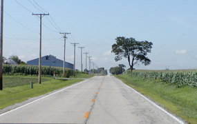
For the most part, Illinois Route 66 glides evenly and easily through the State in a southwest-northeast diagonal alignment between Chicago and St. Louis. The Illinois section of historic Route 66 has a relatively level alignment. Due to Ice Age glaciers that scraped much of the upper Midwest flat, the Illinois Route 66 roadbed was never to offer motorists the thrilling or terrifying switchbacks, dips, and cuts encountered along the southwestern portions of the Mother Road. Unlike many other segments of Route 66, Illinois Route 66 runs through a densely populated, highly developed State. By the mid 1920s, Illinois already had a considerable infrastructure, including a modern road network. When officially commissioned in 1926, Illinois Route 66 simply took over State Route 4, a pre-existing, heavily-used fully paved or “slabbed” two-lane road between Chicago and St. Louis. Thus, while the national span of Route 66 would not be completely paved until 1938, the Prairie State could boast from the very start that its segment of the Mother Road was mud free and “slab all the way.”
At first glance, Route 66 may look inert and fixed, but a little investigation into its history (and archeology) reveals a dynamic process of change and transformation. Due to population and development pressures, Illinois Route 66 received constant undergoing repairs, upgrades, widening, resurfacing, and even rerouting. A distinguishing feature of the history of Illinois Route 66 was the speed of its evolution. From its very first years, engineers worked to bypass as many rural towns as possible to ensure a speedy and unobstructed flow of the ever-increasing traffic between Chicago and St. Louis. Thus from the time of its birth, Illinois Route 66 was already moving away from its classic main street course toward the model of its interstate successor and its own demise.
With the designation of Route 66 as a strategic defense highway during World War II, the process of change accelerated. While traffic to and from the great ordnance factories outside Chicago was critical to feeding the nation’s hungry war machine, it also devastated the Route 66 roadbed, which had not been built to sustain the constant flow of the heavy load bearing munitions trucks. Even as the war raged, the road received significant upgrading, much of it pointing toward the four-lane limited access interstate system of the 1950s. The role of the Federal Government, especially its far-reaching Federal Defense Highway Act of 1941, was critical in the funding of these efforts.
While the story of the road’s physical evolution naturally focuses on the specifics of road construction such as alignment, materials, and methods, the traveler along historic Route 66 might keep in mind that these remarkable engineering feats not only left their mark on the earth’s surface, but also upon people’s lives. Every change in the Mother Road type and its route meant something good or bad for the people along the road. A major rerouting could bring welcomed business and travelers to the new corridor, but it also could painfully wound the areas left behind. The modern upgrade to a four-lane, limited access road was a boon to motorists but could spell disaster to the bypassed roadside establishment. The story of Route 66 is about individuals and businesses adapting, successfully or not, to the winds of change. In the course of its many transfigurations over the decades, the Mother Road gave--but also took away.
The Road Segments
Route 66 in Illinois is a very tenacious road. Although decommissioned in 1977, the Prairie State’s portion of the Mother Road endures, often under new designations, and all but about 13 miles of the final alignment remains traversable. The six road segments below are listed in the National Register of Historic Places. Individually and collectively they offer the traveler insights into the engineering achievement and evolution of Illinois Route 66. In terms of their period of historic significance, the segments of Route 66 Carpenter Park, Illinois Route 4/North of Auburn, and Route 66, Girard to Nilwood, evoke the engineering and transportation developments of the 1920s and 30s. The segments of Alternate Route 66, Wilmington to Joliet, Route 66, Cayuga to Chenoa, and Route 66 Litchfield to Mount Olive, are significant as wartime and postwar upgrades during the years 1942 to 1955. Road segments are listed geographically east to west.
Alternate Route 66, Joliet to Wilmington (1942-1956)
This road segment, currently designated Illinois Route 53, stretches for 15.9 miles between Joliet and Wilmington. The original 1920s era road served as an Alternate Route 66 around Joliet. The impacts of World War II and the Federal Government are central to this segment’s story. Due to the punishing wartime traffic to and from the nearby Kankakee and Elmwood ordnance plants, the original two-lane highway was replaced with a limited access four-lane divided highway constructed between 1942 and 1945. It was authorized and funded by the Federal Defense Highway Act of 1941. In order to sustain the wear and tear of wartime traffic, updated construction methods were applied, including application of a special sub base of gravel and stone on top of the older roadbed, and a divided 24-foot wide roadbed with 10-inch thick Portland cement slab. This segment remained a major transportation artery until the coming of interstate I-55 after 1956. Aside from a new macadam overlay, much of the road’s original 1945 character remains. Travelers should look for the 1942 Union Pacific Overpass near the northern end of the segment’s boundary and four remaining box concrete culverts.
Route 66 by Carpenter Park (1922-1936)
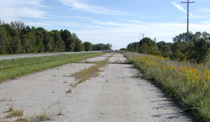
This short, surviving segment of abandoned roadbed, extending for about one quarter mile in Springfield Township, offers the traveler the sensation of visiting not only a road but an archeological site, for it has not seen automobile traffic since 1936. The two-lane, 16-foot wide road reflects the prevailing engineering and design methods of its time of construction in 1922. It is also a good example of how existing paved roads were merely redesignated Illinois Route 66 at the Mother Road’s inauguration in 1926. In 1922, this 16-feet wide roadway was paved with a mix of cement and gravel, with expansion joints placed every 30 yards. Parts of the road are still flanked by its original four-foot gravel shoulders and four inch curbs. This segment’s life as Route 66 was short, for almost immediately engineers began work on a new, wider (four-lane) alignment a few yards to the east completed in 1936. The Carpenter Park segment remains largely intact because it has not carried traffic since 1936, although it is missing its bridge over the Sangamon River (The Old Iron Bridge). With the decommissioning of the road in 1936, the bridge was dismantled, leaving only concrete abutments. This segment is now a part of Carpenter Park in Sangamon County. Visitors are welcome to walk on this stretch of Route 66 surrounded by a forest preserve of native hardwood.
Route 66, Cayuga to Chenoa (1943-44; 1954-55)
The original 1920s state-of-the-art pavement of this segment boasted a width of 18 feet and a Portland cement slab six inches deep. Like the Route 66 Alternate between Wilmington and Joliet, this 18.2-mile segment stretching from Cayuga to Chenoa proved woefully inadequate to carry the burden of Route 66’s World War II mission. The excessive weight and volume of wartime traffic wreaked havoc on the thin roadbed, necessitating a serious upgrade. A 1943-44 wartime makeover included two lanes of 24-foot wide, ten-inch thick concrete. The sections were generally striped for 11 foot driving lanes (an extension of two feet over the older pavement). The southbound lanes, constructed directly over the older roadbed, were finished in 1944, and the northbound lanes were completed in 1954-55, together creating a four-lane highway with a center median. Today the northbound lanes have a new macadam overlay, but the southbound lanes retain, for the most part, their original concrete surface. The segment retains six historic bridges.
Illinois Route 4, North of Auburn (1921-1932)
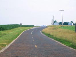
This segment consists of two sections: a 1,277 foot section of 16-foot wide Portland cement dating from 1921, and a 1.53 mile section, overlaid with brick from 1932. Originally part of State Route 4, both sections illustrate early highway era construction methods. They are well-preserved examples of Route 66’s early years in Illinois, when the newly designated national highway simply took over existing paved roads in 1926. The served as part of Route 66 until a 1930 relignment of the Mother Road south of Springfield rerouted traffic to the less populated eastern side through Litchfield, in order to speed up the flow of traffic by avoiding as many towns as possible. The 1,277-feet concrete section of this segment briefly reverted to its State Route 4 designation before being abandoned in a 1932 relocation of the State road. The second 1.53-mile section was incorporated into the 1932 modifications and resurfaced with brick at the same time. Today known as the Auburn Brick Road, it contains two original single span concrete bridges constructed in 1920 and paved with brick in 1932.
Route 66, Girard to Nilwood (1919-1931)
This segment underscores the fast paced evolution of Route 66 in Illinois. Designated as a part of the Mother Road in 1926, it was quickly replaced in 1930 with a major realignment to the east. Constructed in 1920 as part of old State Route 4, this short-lived section of Illinois Route 66 is typical of the engineering and construction methods of the post-World War I era. This was a time of genuine transition in road construction, often combining horse and mule with World War I state-of-the-art trucks and machinery. The road’s cross section included two eight-foot wide lanes with four to seven foot wide gravel shoulders. The Portland cement slab was generally six inches thick. Although cracked in places, its current concrete pavement is original. The road segment retains five of its original concrete box culverts and an original, 1920 single span concrete bridge.
Route 66, Litchfield to Mount Olive (1943-1955)
As with Alternate Route 66 from Wilmington to Joliet and Route 66 from Cayuga to Chenoa, the Mother Road’s stretch from Litchfield to Mount Olive was transformed as a result of World War II. By 1942, the original alignment in this area had significantly deteriorated under the stress of wartime traffic. Authorized by the Federal Defense Highway Act of 1941, the approach to constructing this segment shows both the pressures of wartime conditions and the long-term postwar vision (already present in 1941) of transforming Illinois Route 66 into a modern, limited access freeway between Chicago and St. Louis. The new two-lane road, with a pavement of Portland cement 24-foot wide and 10 inches thick, was set down just to the west of the older route, which had been constructed in 1930-31. The older, deteriorated pavement was kept in service until the new alignment was complete. When the new Route 66 southbound lanes were completed in 1943, the older alignment was designated Old Route 66 and remained open to local traffic. Construction of the northbound lanes had to wait until after the war, but when completed in 1954-55, they formed, along with the 1943-44 southbound lanes, a state-of-the-art four-lane highway with a center median–-a veritable precursor to the Interstate freeway. This segment received a Cost-Share Grant from the National Park Service Route 66 Corridor Preservation Program in 2002.
|
Joliet to Wilmington: Begin at Patterson Rd. in Joliet and travel south on Highway 53 toward Wilmington. The course ends at the junction of Highway 53 (Alternate Route 66) and Illinois Route 102 (Water Street) in downtown Wilmington.
Carpenter Park: The entire segment is contained within the boundaries of Carpenter Park in Sangamon County. The northern boundary is the road segment’s intersection with Cabin Smoke Trail. The southern boundary is the abutment of the Old Iron Bridge on the Sangamon River, a quarter mile to the southeast.
Cayuga to Chenoa: From Odell, travel south on Odell Rd. toward Pontiac to Cayuga. From Cayuga, take Pontiac Road into Pontiac. Follow the gradual curve right, then curve left onto Division Street. Cross North Creek, then curve right onto Lincoln, and left onto Ladd Street. Cross the junction with Howard. At Reynolds, turn right with Highway 116. Turn left onto Bypass 66 and follow the Frontage Road through to Chenoa.
Auburn: To reach the first 1,277-foot section, travel south on Highway 4 to Alpha Rd. Go west on Alpha Rd. The segment is located on Alpha Rd. between Highway 4 and Curran Rd. The Auburn Brick Rd. is located between Chatham and Auburn on Snell and Curran Rds. Heading south from Chatham on Highway 4, take a left on Snell Rd., which is historic U.S. Route 66. Snell Rd. will curve south and turn into Curran Rd. before rejoining Highway 4.
Girard to Nilwood: Heading southbound on Highway 4 toward Girard, turn right on Madison St. and left on 6th St. Continue south on 6th St. across Highway 4. Turn right on Wylder, then left past the railroad underpass. Turn right on Morean Rd. Turn left on Pine and right on Morean St. in Nilwood, which will reconnect with Highway 4. Stay ahead across. The road segment ends at 4.0 miles at the intersection with Illinois Route 4 at the west end of Moraine Street.
Litchfield to Mt. Olive: Traveling westbound, from Interstate 55 take the 13th Street exit into Litchfield. Head south on “Old US 66 1940-1977.” This road will meet up with “1930-1940 Historic 66 at North 10th Ave. Continue south on Route 6. Cross St. James Road, then turn left on Old Route 66 St. into Mount Olive. Follow Old Route 66 Street across the Junction of Highway 138 and on out of town.
Joliet to Wilmington
National Park Service
Route 66 Corridor Preservation Program
Litchfield to Mt. Olive
National Park Service
Route 66 Corridor Preservation Program
Auburn Brick Road
National Park Service
Route 66 Corridor Preservation Program
For additional information on driving Route 66 in Illinois, visit these websites:
Route 66 Association of Illinois
The Route 66 Association of Illinois is a not-for-profit corporation dedicated to preserving, promoting, educating and enjoying Route 66 in Illinois. It's members hail from all over the US and many other countries. The Association sponsors the Route 66 Hall of Fame in Pontiac Illinois, stages an annual Chicago-St. Louis Motor Tour in ...
Illinois Route 66 Scenic Byway
The experiences you’ll find here are as unique, fun and memorable as the road is long. Route 66 defined a remarkable era in ...
Illinois Route 66 National Scenic Byway
In 1926, America was on the move and Route 66 was the way to "motor west." The road gave birth to service stations, motels, diners and of course, often kitschy roadside attractions. Today, Illinois 66 is a continuum of one-of-a-kind connections to the old road in America's agricultural heartland. ...
|

